Friends of Nachusa Grasslands
  • Home
  • About Friends
    • Mission, Leadership, Objectives, and Financials
    • Endowments
    • Heritage Heroes Initiative
    • Friends Annual Reports
    • Newsletters >
      • PrairiE–Update (email)
      • A Prairie Calling (print and digital)
    • Friends Annual Meeting 2022
    • Commenting Policy
  • Plan Your Visit
    • Hours & Parking
    • Directions and Map
    • Visitor Center
    • Pet Policy
    • Public Bison Tours
    • Bison Viewing
    • Hiking >
      • Hiking Guidelines
      • Hiking Destinations
      • Stone Barn Savanna Tour
      • Visitor Center Trail
      • Scavenger Hunt
    • What's In Bloom?
    • Autumn on the Prairie
    • Exploring Nachusa Grasslands on Your Own
    • Things to Do
    • Places to Eat and Stay
    • Local Sites to Visit and Explore
  • Donate
  • Calendar
  • Volunteer
    • Volunteer Opportunities
    • Thursday and Saturday Workdays >
      • Workday Signup
      • Volunteer Workday Safety Protocols
      • Workdays – November to February
      • Leader Workday Safety Protocols
      • Steward Workday Tips
    • Stewardship Teams
    • Workday Email List
    • Steward Login
  • Stewardship
    • Nachusa Stewardship
    • Restorations
    • Planting Histories >
      • Stewardship Unit Planting Histories
      • Planting Histories in Chronological Order
      • Science Symposium Abstracts 2016
    • Stewards and Staff
    • Groups and Committees
    • Available Units
    • Controlled Burns
    • Prescribed Fire Recruitment
    • Restoration Publications
    • Stewardship Resources >
      • Weekly Top Picks
      • Seed Collection Guides
      • Invasive Plant Management
      • Invasive Identification
      • Monitoring
      • Links & Resources
  • Science
    • Science at Nachusa Grasslands
    • Science Grants >
      • Science Grants 2023
      • Science Grants 2022
      • Science Grants 2021
      • Science Grants 2020
      • Science Grants 2019
      • Science Grants 2018
      • Science Grants 2017
      • Science Grants 2016
      • Science Grants 2015
      • Science Grants 2014
      • Science Grants 2013/2012/2011
    • Science Symposium 2023
    • Science Symposium Abstracts >
      • Science Symposium Abstracts 2019
      • Science Symposium Abstracts 2018
      • Science Symposium Abstracts 2017
    • Potential Research Topics
    • Scientific Publications
    • Testimonials >
      • Dr. Holly Jones
      • Dr. Nick Barber
      • Kimberly Elsenbroek
    • Science Videos
    • Become a Community Scientist >
      • About Community Scientists
      • Butterfly Monitoring
      • Calling Frog Monitoring
      • Dragonflies & Damselflies
      • RiverWatch
  • About Nachusa
    • General Info
    • Prairie Smoke Annual Reports
    • Plant Inventory >
      • Common Names
      • Genus Species
    • Animal Inventory >
      • Amphibians
      • Birds
      • Bison Bison >
        • Bison
        • Bison Babies Broadcast Videos
      • Fish
      • Insects
      • Mammals
      • Other Arthropods
      • Reptiles
    • History
    • Jobs
    • Hunting
    • Geology >
      • Geology Part 1
      • Geology Part 2
      • Geology Part 3
    • 30th Anniversary Memories
    • Websites of Interest
  • BLOG AND MEDIA
    • Nachusa Blog
    • In The News
    • Photo Gallery >
      • Spring Photos
      • Summer Photos
      • Autumn Photos
      • Winter Photos
      • Visitor Photos
    • Submit Your Photos
    • Videos
  • Contact Us / FAQs

Nachusa Grasslands

Taking A Bird’s Eye View: GIS And Spatial Analysis at Nachusa

8/11/2020

1 Comment

 
By Erin Rowland
​Summer Science Extern
Picture
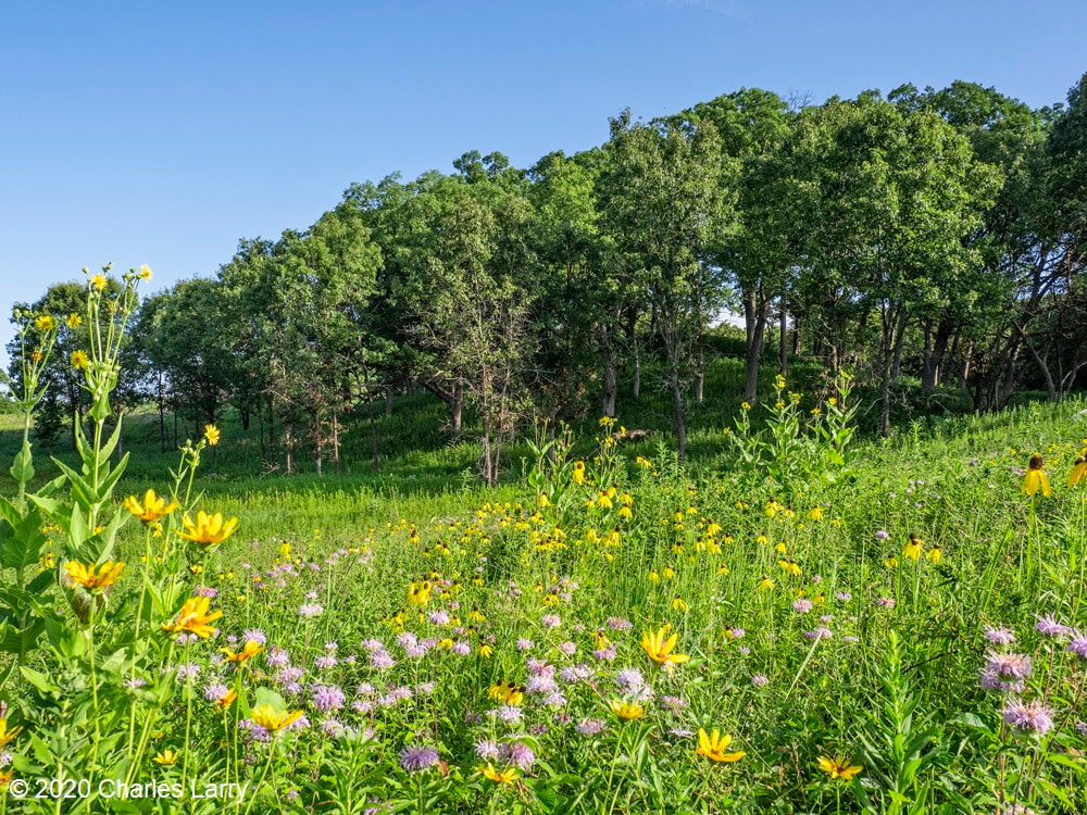
Picturesque restorations like this are made possible by the work of volunteers and stewards on the ground. Science provides a new lens to better understand the impacts of this work.
When I think of prairie restoration, I tend to think of the hands-on. I picture crews of volunteers collecting buckets of seed, or the summer crew fanned out in a line spraying weeds. Even the science done at Nachusa tends to conjure images of researchers trekking through the tallgrass after Blanding’s turtles, rodents, or butterflies. When I pictured my summer as Nachusa’s summer science extern, these were the images that filled my head. I couldn’t wait to spend my weeks under the sun trapping small mammals  and surveying plant diversity. Meanwhile, the universe had other plans. 
​
Because of the COVID-19 pandemic, research looked a little different this year. Many field scientists were able to conduct safe and socially distant work, while some researchers had to cancel their field seasons altogether. I was one of the unlucky ones. Instead of a summer in the field, I spent the summer at a computer. The funny thing is, this turn of events helped me to see the big picture.
Picture
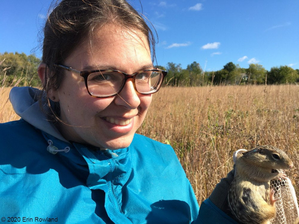
A typical summer of research for me involves lots of small mammal trapping. Due to COVID-19, the 2020 small mammal trapping season was cancelled.
Geographic Information Systems (GIS) is a broad category of science that combines geography with other disciplines to create smart maps and analyze data throughout space and time. It’s a booming field, and it touches every aspect of our lives, whether we see it or not. GIS is used in everything from urban planning to public health to ecology. It allows us to ask and answer really interesting questions such as how the arrangement of land patches and proximity to different types of cover impact everything else on the preserve.

This summer, I spent my time looking at the preserve from above in aerial imagery, trying to understand how all the pieces fit together. I spent a lot of my time converting old images of prescribed burn locations into a digital format, a process that feels a lot like a small child playing connect-the-dots. Tedious as it may be, this labor of love will help us see patterns through time in a new way. We can now easily ask how frequently certain areas of the preserve are burned and what that might mean for the plants and animals who live there. 
Picture
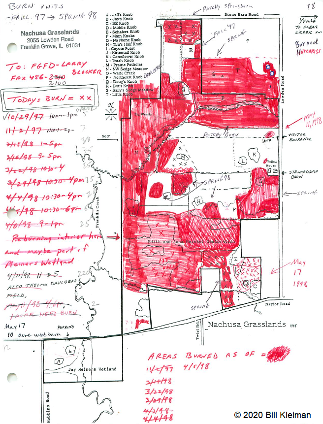
Historically, records of prescribed burns were hand-drawn and not very precise. Our new digital fire maps are uniform and standardized, which will improve our ability to use the information.
The second aspect of my work this summer was a bit more practical. Collaboration is one of the most valuable components of research at Nachusa Grasslands, and it’s part of what makes me so excited about working there. There’s such great diversity in the projects at Nachusa, as you can clearly see from the spectrum of projects funded by the Friends of Nachusa Grasslands science grants. One of my goals this summer was to compile a map of all the long-term research sites on the preserve, as well as to describe the types of data collected on these plots. By making information about data more broadly accessible, we can support better science that can benefit Nachusa and other prairie restoration sites. Researchers are better able to collaborate if they know what data exists and to whom to talk about it. 
Picture
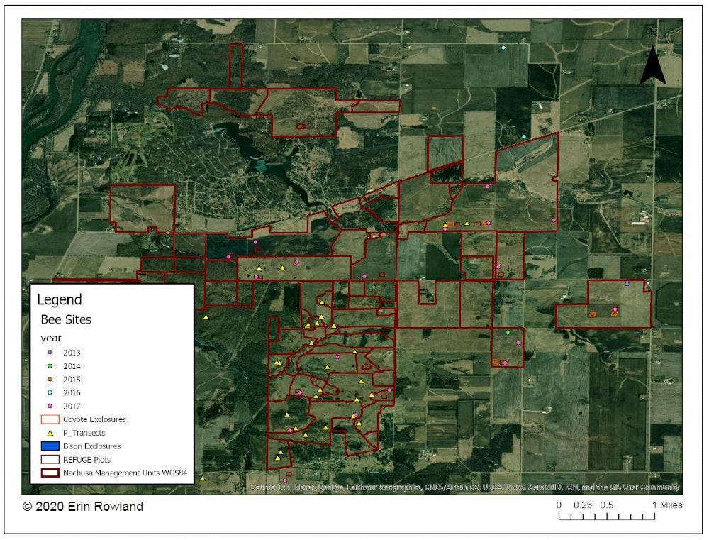
A map of long-term research sites at Nachusa will help researchers to more effectively collaborate and establish new projects more easily.
The third part of my work this summer was beginning to understand the impact of human-made boundaries on a natural system. Plants and animals don’t care at all about the arbitrary places we draw our lines on a landscape. A piece of habitat is all the same to them, regardless of who owns it. This means that we have to be aware of the places where we create borders and boundaries and understand the impacts that they may have. A simple mowed path for a stewardship vehicle may seem minor to us, but might represent an insurmountable obstacle to a vole. 

One of the most exciting revelations of my work this summer is a success story in the tallgrass. I conducted analysis to understand how insulated different areas of the preserve are from the surrounding landscape. I created a heatmap to illustrate distance from the edge of the preserve, an attempt to classify land by how far it is from the proverbial “edge.” The results showed that the best-insulated area of the preserve is part of the original purchase that established Nachusa Grasslands. Not only was a beautiful portion of remnant prairie preserved, but the land around it was converted to create a pure prairie landscape with a buffer of protection from the surrounding agriculture and development. ​
Picture
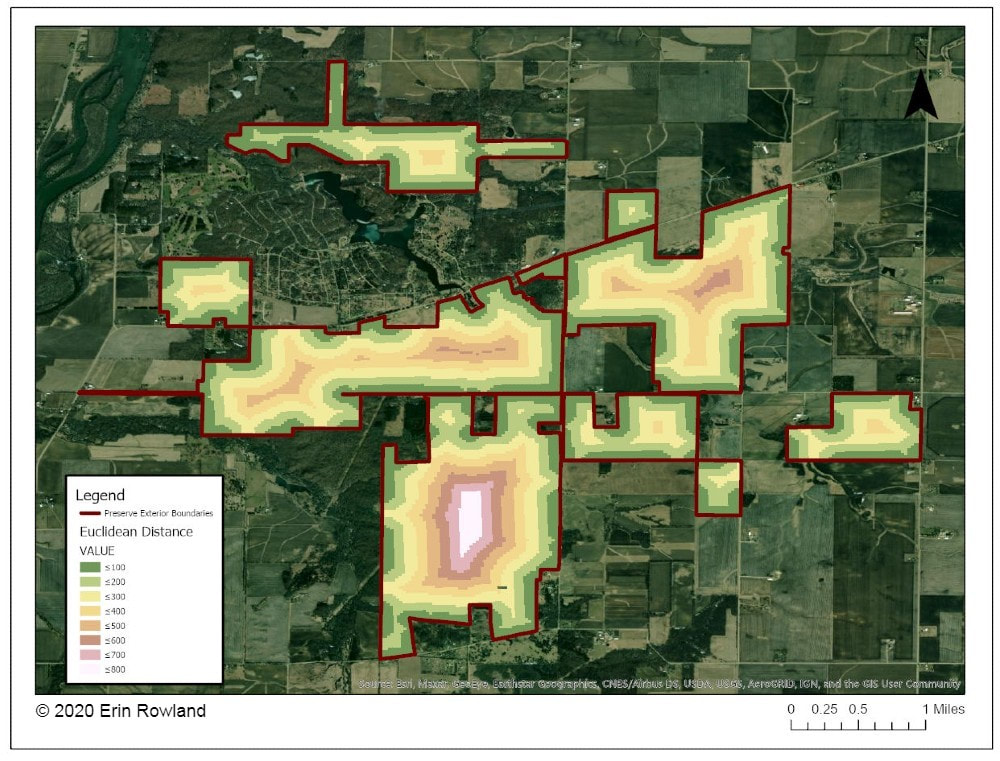
This map helps us to understand how close various areas of the preserve are to non-prairie edge. We can see which areas are the most insulated from external impacts.
Management happens at a variety of scales. Many decisions are made at the smallest scale: an invasive species can be removed from a part of a unit, and seeds can be collected from a rich patch of big bluestem to be planted next year. What’s harder to consider is how these seemingly small decisions work in tandem to create larger-scale impacts. The preserve looks different from above than it does on the ground. The challenge for managers is to be able to simultaneously see the prairie and the plants, as well as the forest and the trees. To meet the needs of a prairie restoration, one has to imagine the view of a turtle or a ground squirrel, in order to imagine a patch of grass as your whole world. At the same time, one must consider the big picture. Making decisions on the small-scale for the sake of specific animals or desirable plants can negatively impact the overall health of a system.

What excites me the most as a researcher at Nachusa is the opportunity to do science that helps us make better decisions in restoration. By taking a step back out of the grass this summer, I had the chance to look at the preserve from a different perspective. I gained a new appreciation for the complexity of a prairie restoration project and the multi-faceted decision-making with which land managers are tasked. Now I look forward to taking my maps and figures and using them to ask more questions about how our work changes the landscape and how the landscape changes our work.

Erin Rowland's ongoing research on small mammals and landscape ecology is supported with a Scientific Research Grant from the Friends of Nachusa Grasslands. The Nachusa summer science externship is supported by The Nature Conservancy.

To get involved withe the critical on-the-ground work at Nachusa, consider joining our Thursday or Saturday Workdays or giving a donation to the Friends of Nachusa Grasslands. Donations to Friends can be designated to Scientific Research Grants.

If you are interested in learning more about Erin's small mammal work, check out the recent blog by Jessica Fliginger or contact Erin to learn about opportunities to volunteer!


Picture
Erin Rowland is a second-year PhD student at Northern Illinois University in Dr. Holly Jones' Evidence-Based Restoration Lab. She graduated from Concordia University, Nebraska with a bachelor's degree in biology and minors in chemistry and geography in 2019. Her research interests include small mammal ecology and multi-scale landscape ecology. She is also interested in pedagogy research and science communication. You can find her online at her website or on Twitter @ErinGRowland.
1 Comment
James McGee
8/17/2020 05:40:43 pm

I like Bill’s map. Now I finally know where some of the areas people have been talking about are located.

However, I think GIS mapping is the future of conservation. Once the data is in a computer, so many tasks can be automated. It makes so many analyses possible that would not have been possible before. Data also has a backup which prevents it from being lost in the event of a disaster.

As someone who works on invasive species control, I look forward to the day a drone can fly over a site pinpointing every invasive species on a map. With the battle field recorded, a computer could determine the optimal route to accomplish the most work. This would be very useful once control was to the point that only a small number of scattered invasive species were present throughout the site. Factors like the fine grain quality of the natural community, location of invasive species, density of the invasive species present, amount of labor available, and predicted weather could all be synthesis to make a battle plan for the day, week, and season. A program could even tell you how much herbicide you would need.

The long-term benefit from having an automated way to map invasive species and record data is you could easily calculate the effectiveness and cost of different methods of doing the work and make changes that would have predictable and tangible impacts. As technology is developed for agriculture, I expect it will also be adaptable to restoration practices. This future might be coming sooner than we might have previously imagined.

Reply

Your comment will be posted after it is approved.


Leave a Reply.

    Blog Coordinator

    Dee Hudson
    I am a nature photographer, a freelance graphic designer, and steward at Nachusa's Thelma Carpenter Prairie. I have taken photos for Nachusa since 2012.

    Editor

    James Higby
    I have been a high school French teacher, registered piano technician, and librarian. In retirement I am a volunteer historian at Lee County Historical and Genealogical Society. 

    Categories

    All
    Autumn
    Bison
    Citizen Science
    Controlled Burns
    Exotic And Invasive Plants
    Grants
    Grassland Birds
    Harvest
    Illinois Prairies
    Insects
    Land Restoration
    Land Stewards
    Native Bees
    Native Grasses
    Native Wildflowers
    Oaks
    Photography
    Planting
    Plants
    Preservation
    Sandstone
    Science
    Shrubs
    Soil
    Turtles
    Volunteer
    Water Quality
    Wetland
    Wildlife
    Winter
    Woodland Restoration

    Archives

    February 2023
    January 2023
    October 2022
    May 2022
    January 2022
    December 2021
    August 2021
    May 2021
    April 2021
    February 2021
    December 2020
    October 2020
    September 2020
    August 2020
    July 2020
    June 2020
    May 2020
    April 2020
    March 2020
    February 2020
    December 2019
    October 2019
    September 2019
    August 2019
    July 2019
    June 2019
    May 2019
    February 2019
    December 2018
    June 2018
    May 2018
    April 2018
    March 2018
    December 2017
    November 2017
    October 2017
    September 2017
    August 2017
    July 2017
    June 2017
    May 2017
    April 2017
    March 2017
    February 2017
    January 2017
    December 2016
    November 2016
    October 2016
    September 2016
    August 2016
    July 2016
    June 2016
    May 2016
    April 2016

    RSS Feed

CONNECT WITH US

PrairiE–Updates Newsletters

SUPPORT US                      

​Donate | Volunteer                  

FIND US ​

Map & Directions

2075 Lowden Road             |           Franklin Grove, IL 61031              |             Contact Us


PRIVACY POLICY
© 2023 FRIENDS OF NACHUSA GRASSLANDS The content on this website is owned by us and our licensors. Do not copy any content (including images) without our consent.
  • Home
  • About Friends
    • Mission, Leadership, Objectives, and Financials
    • Endowments
    • Heritage Heroes Initiative
    • Friends Annual Reports
    • Newsletters >
      • PrairiE–Update (email)
      • A Prairie Calling (print and digital)
    • Friends Annual Meeting 2022
    • Commenting Policy
  • Plan Your Visit
    • Hours & Parking
    • Directions and Map
    • Visitor Center
    • Pet Policy
    • Public Bison Tours
    • Bison Viewing
    • Hiking >
      • Hiking Guidelines
      • Hiking Destinations
      • Stone Barn Savanna Tour
      • Visitor Center Trail
      • Scavenger Hunt
    • What's In Bloom?
    • Autumn on the Prairie
    • Exploring Nachusa Grasslands on Your Own
    • Things to Do
    • Places to Eat and Stay
    • Local Sites to Visit and Explore
  • Donate
  • Calendar
  • Volunteer
    • Volunteer Opportunities
    • Thursday and Saturday Workdays >
      • Workday Signup
      • Volunteer Workday Safety Protocols
      • Workdays – November to February
      • Leader Workday Safety Protocols
      • Steward Workday Tips
    • Stewardship Teams
    • Workday Email List
    • Steward Login
  • Stewardship
    • Nachusa Stewardship
    • Restorations
    • Planting Histories >
      • Stewardship Unit Planting Histories
      • Planting Histories in Chronological Order
      • Science Symposium Abstracts 2016
    • Stewards and Staff
    • Groups and Committees
    • Available Units
    • Controlled Burns
    • Prescribed Fire Recruitment
    • Restoration Publications
    • Stewardship Resources >
      • Weekly Top Picks
      • Seed Collection Guides
      • Invasive Plant Management
      • Invasive Identification
      • Monitoring
      • Links & Resources
  • Science
    • Science at Nachusa Grasslands
    • Science Grants >
      • Science Grants 2023
      • Science Grants 2022
      • Science Grants 2021
      • Science Grants 2020
      • Science Grants 2019
      • Science Grants 2018
      • Science Grants 2017
      • Science Grants 2016
      • Science Grants 2015
      • Science Grants 2014
      • Science Grants 2013/2012/2011
    • Science Symposium 2023
    • Science Symposium Abstracts >
      • Science Symposium Abstracts 2019
      • Science Symposium Abstracts 2018
      • Science Symposium Abstracts 2017
    • Potential Research Topics
    • Scientific Publications
    • Testimonials >
      • Dr. Holly Jones
      • Dr. Nick Barber
      • Kimberly Elsenbroek
    • Science Videos
    • Become a Community Scientist >
      • About Community Scientists
      • Butterfly Monitoring
      • Calling Frog Monitoring
      • Dragonflies & Damselflies
      • RiverWatch
  • About Nachusa
    • General Info
    • Prairie Smoke Annual Reports
    • Plant Inventory >
      • Common Names
      • Genus Species
    • Animal Inventory >
      • Amphibians
      • Birds
      • Bison Bison >
        • Bison
        • Bison Babies Broadcast Videos
      • Fish
      • Insects
      • Mammals
      • Other Arthropods
      • Reptiles
    • History
    • Jobs
    • Hunting
    • Geology >
      • Geology Part 1
      • Geology Part 2
      • Geology Part 3
    • 30th Anniversary Memories
    • Websites of Interest
  • BLOG AND MEDIA
    • Nachusa Blog
    • In The News
    • Photo Gallery >
      • Spring Photos
      • Summer Photos
      • Autumn Photos
      • Winter Photos
      • Visitor Photos
    • Submit Your Photos
    • Videos
  • Contact Us / FAQs